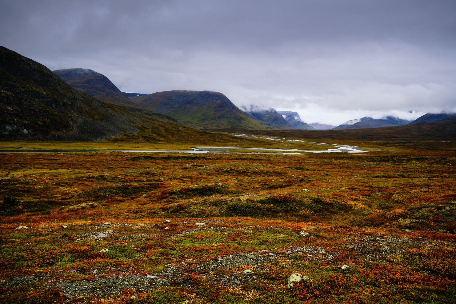
The King’s Trail, or in Swedish Kungsleden, is a trail in northern Sweden, far beyond the Arctic Circle. After I was forced to cancel my participation in the 2026 Scotland crossing, I looked for another route, up to a week’s hike, that I could set out on in late August/early September.
The King’s Trail is a long trail of about 460 km, starting in Abisko, about 15 km from the border with Norway, and ending in Hemavan. It usually takes about 3 weeks to complete it, but since I only had a week, I chose to do only 180 km, from Abisko to Kvikkjokk.
The departure date was August 30th, when the huts along the trail begin closing around the 10th to 15th of September, meaning I was really right at the edge of the season.


I arrived in Stockholm and met an old friend there, Eric, from the early days of the internet, around 1996, when I first started playing a game called DuneMUD, and then became one of its developers. We started the evening with a fancy hamburger, at a pub whose owner had volunteered on a kibbutz in Israel in the 80s, and continued into an evening of beers. During the evening a few of Erik’s friends joined us, among them Tony and Ronny.
Tony is a drummer, covered in tattoos. All evening he drummed on the table. I asked him what he likes most about Sweden, and he said he likes most that he feels the taxes he pays actually work for him. I asked Ronny what he does for a living. He works in a fascinating role: there’s a body in Sweden responsible for taking ideas and difficulties from citizens, and processing them into a unified list from which politicians and legislators pick items and work on them. A real official state body, available to every citizen. Pretty cool, huh?
I gave out after the fourth beer and went to sleep.

The next day I got on a flight to Kiruna. Before boarding, I had to watch my bag lying under Swedish rain for about an hour and a half. On one hand, a bit annoying, on the other hand, I knew everything inside was protected from water, so I was calm.
On the way to the Abisko tourist center, an hour’s drive from Kiruna, I got to talk with the driver, a big Norwegian guy wearing pants made of reindeer hide.
It turns out Kiruna is a mining town. There’s a large iron mine here, producing about 85 percent of all of Europe’s iron. How big? 900 km of roads underground big. The mine also causes the town to be not so stable, and they relocate houses elsewhere. Residents have a choice, either to receive financial compensation, or a new apartment in one of the new buildings built for them.
About 4,000 people work in the mine itself, and another 10,000 or so work around it. 45 percent of the workers in the mine are women. He claims that ever since they discovered that letting women operate heavy equipment is safer, women have become an inseparable part of the work.
People here get double pay and work a week on, week off schedule. They have quite a lot of money, and there are Cadillac farms here. Yes, really. They buy Cadillacs from the US, fix them up and… that’s basically it. A few hundred Cadillac cars standing on the farm. A very impressive sight. During the week they’re not working the mine, they hunt. That’s the reason the ratio of people to dogs is one to four, for every person, four dogs.


In the evening I ate a delicious dinner, and went to sleep early, knowing that tomorrow a very long day was waiting for me.


I woke up, ate breakfast (a buffet, of course), got ready quickly, and at seven o’clock, after a traditional photo at the start of the trail, I started walking in an Arctic forest, full of low birch trees. They’re very different from the birch you can see further south, the southern birch trees are straight and tall, but they don’t survive so far north, and they’re much smaller, less straight and apparently much more flexible. In winter ice accumulates on their treetops, and they simply fold all the way to the ground, so that the treetop touches the ground, and that’s how they freeze for the whole winter, only to thaw in autumn and straighten up again.

Already after 10 minutes of walking, you reach an insane canyon with impressive geometric rocks, a kind of Hexagon Pool that we have in Israel, but much bigger, much colder, with much more water and much more noise. The water flows so fast and makes so much noise, that it’s very hard to hear anything beyond it.


One of the things that accompanied me throughout the whole trail is the amount of mushrooms and wild berries growing simply everywhere! There were quite a few times I simply had to walk on blueberries. I saw three main types of berries: a kind of wild blueberry (Bilberry), whose color is really dark purple, and red Lingonberries, which simply burst in your mouth. I ate a lot of both these kinds along the trail. There are also black Crowberries, which apparently are also edible, but I didn’t like their taste.


In addition, I came across tons of kinds of mushrooms!


The morning started without rain, and continuing the luck I had in Scotland (half an hour of rain out of almost two weeks of walking), I started imagining that I simply push clouds away and they’re afraid to cast their waters on me. Little did I know… At 9 in the morning it started drizzling, and pretty much from that moment until the morning of the fourth day, rain did not stop falling on me.
In fact, for four days I didn’t see the sun at all, but I got dramatic clouds and insane scenery already from the first day.
Walking, slowly the Arctic forest with the birch trees disappeared behind me and gave way to open, wide scenery, with insane red/yellow/brown/green colors, like in a postcard. That’s also the reason I chose this exact season, in my opinion it’s much more impressive than midsummer, when everything is green.


While walking and getting more and more impressed by the crazy scenery, I tripped on one of the wooden beams I was walking on (my foot simply slipped sideways), and crashed forward. From that moment, I walked on those wooden beams a bit slower.
By the way, the reason these wooden paths exist is twofold. The first is to protect nature, and the second is to protect the walkers in especially difficult areas. The whole trail is full of rock fields, deep mud and swamps, and it would be very hard to pass there without the wooden paths.
Along the way I met Pascal. Pascal is a nursefrom Switzerland, and he too, like me, was on his way to Kvikkjokk.
The day was very long. 12.5 hours of walking, in the rain, about 36 km total, left me very tired and very wet. I arrived at the Alesjaure hut right 20 minutes before the shop closed (20:00), and I was so tired that I decided, I deserve it, today I sleep in the hut and not in the tent. I paid about 200 shekels for the privilege of sleeping together with 10 more people on the second floor of a bunk bed, made myself some food, talked with a few hikers (I found out they were from Czechia), and went to sleep, exhausted from the day I’d had.
I got up early in the morning knowing that today would be much easier, a distance of about 25 km, compared to 36 km the day before, with less climbing. How naive I was…
The clouds were heavy and didn’t promise a sunny day, but they created perfect morning lighting. I took one of the photos I like most from this trek, with a Sami village in the background.

I crossed the bridge next to the camp, and saw a few tents. Somewhere inside, I was very glad I’d slept in the hut, walking at night, in the dark, toward the camp to the bathroom area, would probably have been very very unpleasant. The bathrooms, by the way, everywhere, are dry toilets, a stall with a hole you do your business into. At least there was toilet paper…


The rain didn’t stop, and somehow the socks I’d hung up in the hut hadn’t dried, but it didn’t matter, because my socks are merino wool (Darn Tough) and half a minute from the moment I put them on, they started warming my feet, even though they were wet, and they dried within about an hour.
The day was supposed to be split into two parts, in the first 17 km a climb from a height of 780 meters to a pass at a height of 1,142 meters, called Tjäktja, and then a descent along another 8 km or so to a height of 825 meters. Overall, really not bad, and I expected to finish these 25 km in about 9 hours.
What I didn’t know is that the terrain of this day is full of boulders, and I spent the whole day walking or jumping over big rocks, some the size of a football, some the size of a motorcycle, and almost all of them with sharp edges that over time simply hurt to step on. That’s the reason this day is remembered by me as “the most painful day.”


The scenery of course is insane, and all of nature is painted red-yellow-green, with gray skies above. Lots of crossings of streams and rivers, most of them have a proper bridge, whether it’s a suspended metal bridge, or simply two wooden beams laid over the stream.
There were a few breaks from the rain, precisely when I was about to cross a river (one of the few that was knee-height and had no bridge over it), I stopped and looked back, and saw an insane rainbow!

I climbed for hours, but apart from the last section, the climb wasn’t very steep. The clouds were very low, and most of the time the rain kept falling.

About 5 kilometers before Tjäktja, I stopped someone and asked him about the water situation at the pass, whether I needed to take extra water. He said there isn’t much water there, so I filled another liter of water in my bottle.


In hindsight it turned out I simply carried this extra liter on my back for nothing on the climb to the pass. There are people who walk the Kungsleden with just a cup, there’s simply so much flowing water and there’s no way to be without water for more than a handful of kilometers. I only used the 650 ml bottle I bought in Sweden, and it was completely enough for me. I climbed up to the pass, and simply poured out the water I had in the liter bottle.


I rested up top near the emergency hut, and talked with two guys from Czechia. Both experienced hikers, and one of them even finished the northern half of the Israel National Trail! He says the Israel National Trail is always included in the list of one of the 20 most beautiful trails in the world, and that it’s very special. National pride!

The descent down to the Tjäktjavagge valley was very steep, and apparently if not for my hiking poles, I would have had to crawl down in some places. From a distance I saw a cloudburst, inside the valley. The valley looked very flat, but there are tons of rock fields there and walking in it was very hard and painful. In some places it seemed like I was walking at the pace of a turtle.


I arrived at Salka at 19:30, about 3 hours behind schedule. I was tired and my feet were killing me from a whole day on rocks, so I again decided to have mercy on myself, and slept in the hut. There I joined five people already sitting around the table, talking about something very intensely. On one side was a young woman from Ukraine with an acquaintance of hers, and on the other side were three Dutch guys. She was busy explaining to them the situation between Ukraine and Russia, and they, for their part, were busy saying that you have to listen to all sides. I joined the conversation, and when they asked me where I’m from, I said from Israel, and that if they want, once they settle Russia-Ukraine, we can also talk about Israelis and Palestinians, but we didn’t get to that (and maybe it’s good that we didn’t).
During the discussion, suddenly the whole dim room (there’s no electricity there), was flooded with very strong glowing orange light! We looked outside and saw the sun hiding behind a mountain, with clouds behind the mountain, which created a very special sunset, that for about 10 minutes flooded the whole valley with orange light. Photo attached, no editing.


This morning also didn’t look promising. I started walking, and after a few kilometers reached another emergency hut, where I also stopped to eat breakfast. There too were two hikers from Czechia, and no, these weren’t the same people.

After a few hours of walking, around 10:30, I arrived at Singi, another hut, where I stopped for a break. Singi is located a kilometer from a Sami settlement (that’s the people who live in this area, the Sami) called Kårtjevoulle.


The photos below are the last photos I took with the camera that day, at 10:40 in the morning. All morning light rain fell. The shoes were wet (but that’s fine, I have Inov8 trailrunners and merino socks), and I wanted to stop on a rock about 100 meters away, in order to take off the shoes and wring out the socks. Exactly as that thought crossed my mind, and completely suddenly, two things happened, a very heavy rain started, a real downpour, and a freezing wind arrived! In the time it took me to cross the remaining 50 meters or so to the big rock, I was completely soaked, down to my underwear. Not only that, the wind was really freezing, and I, who usually isn’t cold, understood that the moment had come to put on rain pants.


A few words about rain pants in my trips. In Iceland there was vertical rain, but I didn’t need the rain pants. In Scotland it barely rained on me, and I already thought, here we go, I’ll never need rain pants. And here, I finally understood why it’s a mandatory item, precisely in these extreme cases.
I put on the rain pants, zipped the rain jacket all the way up and threw the camera deep into the bag. From here began 6 hours of walking in pouring rain and freezing wind. Pretty quickly I simply started ignoring the puddles and walked straight through them, because it was simply pointless to detour around them, even my underwear was wet.
I walked in the valley, next to a raging river swollen from the rain, occasionally meeting hikers who were walking the other direction. The temperature I think was a few degrees above zero, and my hands froze. I’d bought gloves of course at a shop in Stockholm, looked like local manufacture, and asked the seller if the gloves were waterproof. He touched them and said yes. They really felt that way.
But I discovered they were really, really not waterproof, and absorbed water like paper towel. It took me a bit of time to understand that in this situation, I should take them off, because it’s better for the hands to be in contact with freezing wind and rain, than with frozen gloves soaked in water, and indeed, the hands started warming up.
Then I reached a kind of dip in the ground, which gave me shelter from the wind, and there were even remnants of a campfire from less rainy days. I put down the bag, to take a short break, and suddenly, out of nowhere, two Swedish girls appeared, running, with short pants, tiny bags, shouted “Hi!” at me, each in turn, and vanished! I didn’t believe my eyes, but somehow in the few single seconds they passed by me, I managed to snap this surrealist photo on my phone, my bag, the cursed gloves, and two blonde Swedish goddesses in short pants who entered my life for a few seconds and vanished.

I kept descending in altitude, and returned to the tree line, into a birch forest. The moment I entered the forest, the wind calmed down and only the rain remained. I walked slowly through the forest, where there was a crazy amount of blueberries, and stopped every few meters to pick some blueberries and be glad that here, I’d overcome another difficulty.

I arrived at Kaitumjaure around 17:00, and I was so wet, that I understood that today too I’m sleeping inside the hut. I opened the door of the hut, inside were two tables full of people. Everyone stopped what they were doing, to look at who was coming in, and I announced loudly:
I am cold, I am hungry, I am tired and I am happy!
I put down the bag next to the bed, immediately an older British guy approached me who was a head taller than me and significantly broader than me (a kind of two-door refrigerator sort of guy), pushed a beer can into my hand, and said, “Come, sit with us.”
I joined them at the table. A British guy and a family (Czech, of course), with bags full of food for 14 days of walking. On the table were sliced cheeses and a psychotic amount of beer cans, and I also added some food I’d brought with me. At the end of the evening, the volunteer who runs the hut, announced that this group had finished all the beer he had, I think about 40 cans of beer, and that he’s keeping the very last one for himself.
I fell asleep to the sound of the British man’s snoring, who it turned out was a former British special forces guy. His snoring shook the hut, and I think I started to understand what my wife goes through.
Today there were two deadlines. The first is crossing Lake Teusajaure by boat at 09:00, and the second a bus at 14:40 at Vakkotavare. The distance from Kaitumjaure to Lake Teusajaure is 9 km, which means by 09:00 I already needed to cover this distance.
I already understood at this stage that walking the Kungsleden is significantly slower than the pace I’m used to, and in order to arrive on time, I decided I needed to leave at 05:00 in the morning. I woke up at 4 in the morning, got ready quietly and left at 05:00, before sunrise. The clouds were a strange blue-purple color, it was cool, but at least it wasn’t raining on me.


The descent to the lake is one of the steepest I’ve experienced, and there’s flowing water along a significant part of the descent, directly on the trail, inside the birch forest. Somehow I managed to get down, without crashing even once.
I managed to reach Lake Teusajaure at 08:30, and treated myself to a can of Coke. All the cans in all the huts were sold at a discounted price, because due to the end of season, whatever doesn’t sell will have to stay in the hut, and since temperatures drop below zero, they simply freeze and burst.
I got on the boat, and at 09:15 I was already on the other side of the lake.


I entered a lovely birch forest, which began the day’s long climb.

The time is 09:15. The bus is at 14:40, which means I have a bit less than 5.5 hours to cover 16 km. A pace of about 3 km/h, but, and this is a big but, the moment you cross the lake, which is at a height of 500 meters above sea level, a climb begins to a height of about 950 meters. It seemed to me this climb would never end, but 6 hours after the morning began, I was already at the highest point of that day.
Along the climb, I couldn’t help but stop, turn around and photograph the breathtaking scenery.


I had 9 km left and two and a half hours to cover them. A significantly faster pace than what I’d done until now. I walked fast, most of the time at a pace close to 4.5 km/h, on a light descent, crossing streams, jumping over rocks without thinking twice. At some point I reached a stream over which there was a single plank, not secured at all, resting only on two rocks, at a height of about 1.5 meters above the water, with water about another meter and a half deep. I did something reckless (I was very angry at myself afterward, and also a little happy), and simply crossed it, without checking other options (I found out afterward there weren’t any…)
I barely stopped to take photos, but then a few herds of reindeer appeared before me, crossing the trail.

The peak was when I saw a completely white reindeer!


A few more photos:


At last I discovered that Sweden too has sun sometimes…
The time is 14:00. I’m on a dangerous descent, trying again not to crash. To my left, a river and a series of waterfalls. I don’t know how much longer there is to descend, but suddenly, those same two Swedish goddesses pass me (again!!!) running, and shout at me, “Great! You made it! You’re almost there!”
And indeed, at 14:25, I reached the bus stop next to the Vakkotavare hut. I filled up water, the bus arrived, I started boarding it with 30 other hikers who were waiting there (they’d apparently slept at Vakkotavare), and suddenly, at 14:38, Pascal comes running up!
“Eli! I’ve been running after you all day! I thought I wouldn’t make it!”
We arrived at Saltoluokta after an hour on the bus and another 20 minutes or so on a ferry. At this stage, I decided not to continue on to Kvikkjokk, and unfortunately gave up on reaching the Skierfe summit for photos. The weather forecast was really not good, and I had a very long day ahead of me, which would have had to end with trying to find a spot to pitch a tent, after 20:00, in a huge boulder field, and the last thing I wanted was to get stuck without a tent in the dark.
I did the trail at double pace. I always skipped a hut, between Abisko and Alesjaure I skipped Abiskojaure, then I also skipped Tjäktja, Singi, Teusajaure. For most people I met, it took 8 days to cover this distance.
On one hand, it feels very slow to me. On the other hand, it’s not for nothing that 7 meditation stones are scattered along the trail, between Abisko and Nikkaluokta, in memory of Dag Hammarskjöld, the Swedish UN Secretary General who loved hiking in the area and was killed in a plane crash in 1961.


On the first stone it’s written, “The longest journey is the journey inward.”
That’s exactly what these trips are for me. While walking, I experience a wide range of emotions. I curse myself for deciding to go on another adventure in a remote place, and I really laugh with happiness when I overcome the difficulties. Sometimes I cry, alone, because it’s easier for me to cry alone, sometimes I simply miss, and sometimes I’m proud of myself.
On the second stone it’s written “Here and now.” These adventures are the most “here and now.” Nothing matters more than the river crossing, than the flower I passed by, than the sunset, than the heavy rain falling on me. Tomorrow doesn’t matter. Next week isn’t even in my thoughts. The only thing that matters is being in the “here and now.” The other five stones and their meaning, I’ll leave for you to search on Google…
The King’s Trail is a magical trail. It can be very hard, and it can be relatively easy. It can be an adventure with a group of friends, or an adventure of a person with himself and nature. Although I didn’t finish the trail, I have no doubt that in the future I’ll return to Saltoluokta, to keep walking this special trail.
See you in the next adventure!
